Switzerland – Sardona & the origin of the Alps
A lot of us, trail and mountain runners, frequently visit the Alps to compete in famous races like the Matterhorn Ultraks, Sierre Zinal or the Zugspitz Ultratrail. When we have the opportunity we also like to train there and combine it with an active, outdoor holiday. But what do we actually know about the origin of these mountains?
To learn more about the formation of the Alps, we are going to run the Sardona World Heritage road 73. This trail leads us through the eastern part of the Glarus Alps that has been designated as Unesco World Heritage under the beautiful name Tectonic Arena Sardona. This designation is with a good reason. Some 100 million years ago, the African continental plate started moving towards the Eurasian plate. In the following collision between the continents different layers of the Earth’s crust shifted over each other. Even entire seabeds were lifted and ended up as mountaintops in this tectonic crumple zone. There are some places where you can clearly experience this process of mountain formation and the Glarus Alps are one of the best in the world. The most spectacular part in this mountain range is the “magical line”, a thrust fault – or break in the Earth’s crust – where older rock formations were pushed above younger rock. The Tectonic Arena Sardona is therefore a mecca for geologists… and for runners who want to know more about the formation of our beloved mountains.

The Sardona World Heritage road 73 has a length of about 100 km with 7,900 meters of ascends. It runs from the Walensee in the north to the town of Flims in the south of the Glarus Alps. We are going to cover the route in three days together with Maarten Hendriks. Maarten is a Dutch runner who lives in the village of Flums with his wife Maartje and their children Imke, Floortje and Nils. Maarten started running when he was twelve years old and used to organize trail races since 2013 in the Netherlands when he lived there. Now he runs a B&B and is also a trail running guide. The Sardona World Heritage road 73 is actually one of his home trails and he is glad to guide us through it.
On the first day we leave quite late, at 2.30 pm. We therefore have to maintain a brisk pace to cover the 28 km before dark to the Spitzmeillenhütte where we spend the first night. We start with a steep climb (up to 40%!) from the Walensee to the first pass, the Mürtschenfurggel. After crossing this pass, we walk along the flanks of the impressive Mürtschenstock, a limestone formation with several peaks. It’s hard to imagine that this limestone is actually formed out of organic deposits on the bottom of a see, up to 100 million years ago.

After crossing the next pass, we descend to the Murgseen, a group of three mountain lakes in the Murg valley. We eat soup with bread in the Mürgseehütte and quickly continue to the next pass. We walk on the flanks of the Bützistock and Heustock and climb to the last pass of the day, the Wissmeilen pass. Then suddenly we notice the sun setting behind the mountain peaks and we witness one of the most beautiful natural phenomena. The play of light and darkness, clouds and colours is breath taking and we would like to enjoy this for a longer time. But we have to move on quickly and descend to the Spitzmeilenhütte. During the descent we see the full moon rising, again a magical moment! Just before dark we arrive at the hut. We managed the last part without a headlamp and give each other a big high five!


Day 2 – After a nutritious breakfast we leave on time at eight o’clock. Maarten runs as a bonus to the top of the Spitzmeilen, the most famous mountain in this area. I run a lower route, because yesterday’s fatigue is still noticeable in the legs. When we meet again, we run through Alpine meadows with sheep and many cows. Maarten tells me that there are more cows in the mountains every year, which is not a good development in his opinion. The cows trample the slopes and paths and can be heard in many parts of the mountains because of their loud bells. The modern cows are bred in such a way that they became bigger and bigger to produce more milk and meat. A Swiss cow today produces twice as much milk as it did fifty years ago. Also for the cow itself, with a weight of up to 800 kg now, it must not be pleasant to stand on a steep, wet slope.


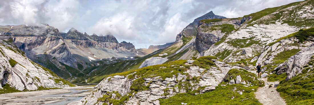
After our cow conversation we leave the meadows and follow a nice ridge to the top of the mountain Fulegg and then another ridge to the Madchopf. Along the way we come across beautiful mountain lakes and have magnificent views over the valley of the Schils, the mountain stream that flows all the way down through Flums, Maarten’s hometown. Then we descend more than 1,000 meters to the village of Weisstannen. The further we descend into the valley, the warmer it gets with the sun high in the sky. Drenched with sweat and tired from the long descent we arrive in the village. We are delighted to receive a warm welcome from the chef of the restaurant Post Ab! in the former post office. He offers us a cool place to sit and a bowl of well-filled soup with bread. We get cake with whipped cream as desert, what a feast!


After lunch we start a long climb of 1,400 meters to the Heidel Pass. Fortunately, we don’t have to do it in one go. After about 500 meters of climbing we arrive at the Waterfall Arena Batöni. Three waterfalls descend from quite a height into a natural arena and join into the Gulfelbach mountain stream. This rare water phenomenon is a local hotspot and for the first time we encounter many mountain hikers. After crossing the new suspension bridge we continue the steep climb to the Heidel Pass and leave the tourists behind. Once at the top, Maarten quickly takes the peak of the Heidelspitz, which is a hundred meters higher. Maarten is training for the Trans Alpine Run and takes every chance to make some extra altitude meters. After the pass it is a bit of climbing and descending to the mountain hut. We even cross some snow fields. After a long day we arrive at the hut, drink some cola and beer on the terrace and enjoy the beautiful view. The Sardonahütte is a lot less luxurious than the previous one. There are no showers and we have to refresh ourselves at a water sink next to the toilets. But the food is tasty and the atmosphere is very good.


Day 3 – After breakfast we leave the Sardonahütte for the last leg. We take a shortcut from the World Heritage route, because bad weather is forecasted in the afternoon. First we climb up to the Trinser Furgga pass and then walk through a glacial valley over the flanks of the Trinserhorn and the impressive mountain Atlas. For the first time we clearly see the magical line of the Glarus thrust. The peaks of these mountains consist of Verrucano. The origin of this rock, an accumulation of debris such as sand and gravel, lies in the dismantling of a mountainous belt that existed long before the formation of the Alps, around 200 million years ago. The boundary between the Verrucano peaks and the underlying, much younger Flysch (sandstone) is razor-sharp.


At the top of the glacier valley we climb steeply to the Segnes pass. To our surprise there is a small mountain hut on top of the pass, an oasis on the rocks! The view over the Sernf valley is great, as is the cola with apple pie. We go down the pass on the same side and pick up the World Heritage route again. We run down through the glacier valley Segnesboden along the foot of the Tschingelhörner. This rock formation contains probably the most visible part of the Glarus thrust which is manifested for many kilometres. It also contains a very expressive rock whole, the Martinsloch. This triangular-shaped opening has become famous due to a unique event. Each year, on 12 and 13 March and again on 30 September and 1 October, just before sunrise, the sun bursts through the Martinsloch opening and lands directly on the church in the village of Elm, located just behind the mountain. This spectacle lasts just a few minutes.

We descend further into the rugged glacier valley. The best of these three days has clearly been saved for last. Wind and weather have gnawed at the mountains over thousands of years: creating glacier-polished rock, moraine, lakes, gravel and flood plains, their structure still well preserved in the primarily untouched landscapes.

For the last part of the descent we follow the Flims Water Trail called “Trutg dil Flem“. We cross seven bridges and have savour views on the bizarre rock formations in the gorge of the Flem and take in the noise of the wild mountain stream. After some nice forest trails we suddenly enter the outer parts of Flims. This is where our mountain journey ends and where the civilized world starts again. With our sweaty faces, muddy shoes and smelly cloths we feel a bit weird between the fashionable people on the terraces, enjoying their holiday. But without hesitation we join them and order two large glasses of wheat beer. Prost!

At the terrace we talk about what makes this area so special. It’s the variation of different biotopes: dry grasslands, moorland landscapes, flood plains and glacier valleys. Nature conversation in the area goes back to 1911, when ibexes were first reintroduced into Switzerland after being wiped out in earlier times. The bearded vulture has also been successfully reintroduced several years ago. The Unesco World Heritage designation is a great recognition, but also means the obligation to protect the area and to preserve it for future generations. And that is a comforting thought.
We learned quite a lot about the formation of the Alps during these last three days. And the race between crumpling, stacking and erosion in these mountains still continues today – the formation of the Alps is not yet complete and the mountaintops still rise 1.5 millimetres a year. We definitely have to come back later to check that out!
More info about the Tectonic Arena Sardona: https://unesco-sardona.ch
More info about Maarten Hendriks and his activities: https://www.spring-inn.ch