Northern Iceland
Running on the boundaries between the Eurasian and North American tectonic plates. Where the earth’s crust cracks open, steams, hisses and where volcanoes regularly spit out their lava. There are few places on earth where you can experience this, but within Europe Iceland is the place to be.
The landscape is developing so fast in Iceland. Almost every year new pieces of land are created by volcanic eruptions. Iceland is therefore also the land of sagas and legends. The stories about trolls and elves are everywhere and most Icelanders are convinced that they exist. And that’s understandable, because this landscape makes your imagination quickly run wild. We head to Northern Iceland for a multi-day running adventure led by Vincent Drost. He is Dutch, but for the love of the Nordic country he is in Iceland for large parts of the year. He gives snowboard lessons and avalanche training during the long winter season and organizes trips for runners in summer. The base of our trip is Akureyri, the capital of Northern Iceland and located along a fjord called Eyjafjörður.
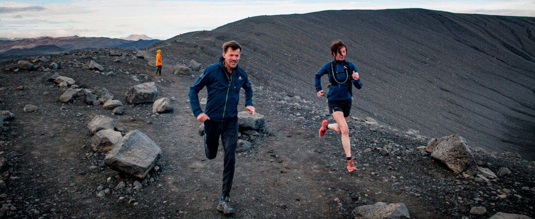
For our first run we meet Erwin van der Werve, a friend of Vincent. He is a Dutch artist and lives just outside Akureyri in a Mongolian yurt, together with his wife Thora Solveig and their children. We are going to run one of his home trails along the river that flows into the Eyjafjörður. The mainly flat route leads through the river valley with green pastures and many flowers. In the distance we see Súlur, the home mountain of Akureyri where the annual Súlur Vertical mountain race takes place. We will also participate in the race later on this week. At the end of the run, when we climb steeply up back to the yurts, we pass a forest planted by his father-in-law. Iceland used to be 20% forested, but after colonization a lot of wood was cut for houses and boats. The sheep that were kept gnawed away the young growth, so that the forests did not recover and only 1% of the land remained forested. To prevent further soil erosion, new forests are now being planted all over Iceland and pioneer plants such as lupine are sown.


The next day Vincent takes us to some geological hotspots where the tectonic plates are moving apart. The first stop is at Mývatn, which means “mosquito lake”. It is a true mosquito paradise because the lake is shallow, the water is relatively warm due to underground heat sources and there is a lot of vegetation along the banks. We end up in a huge mosquito cloud, but luckily they don’t sting. Stories are circulating that horses have suffocated in the mosquito clouds. Fortunately, we’re doing well. Besides mosquito mecca, Mývatn is also very popular with waterfowl such as the Icelandic Goldeneye and the Golden Plover. Aside the lake lie some old volcanic craters. During our trip we also pass several large waterfalls such as the Godafoss, the Sellfoss and the Dettifoss. The latter is the most powerful waterfall in Europe in terms of water displacement, but they all are very spectacular!


Námafjall, “the mining mountain” is the next geological highlight. The geothermal field at the foot of the mountain, called Hverir, is a bizarre collection of hot mud pools and steam vents, with beautiful colors, strange smells and bubbling sounds. Due to the constant emission of vapors and sulfur, the soil of the mountain is unsuitable for vegetation. The mountain was used in the past to extract sulfur and ship it all over Europe for use as gunpowder. We also visit the area around the Krafla volcano, which has been active several times over the past centuries and this is clearly visible in the landscape. The most recent eruptions are from 1975 and 1984.


Then it’s time for some action and we lace up our running shoes. We run a beautiful trail through Dimmuborgir, a nature reserve with jagged, large rock formations that were created 2,500 years ago by eruptions. Borgir means “castle” and the area probably got its name because the rock formations resemble an old and gloomy castle. We run to Hverfell, a cone volcano a few kilometres away. The volcano was formed in a few days in the same period as Dimmuborgir and has a height of more than three hundred meters. There are only three of this type of volcanoes in the world, two on Iceland and one on Hawaii. The climb along the crater wall is a tough one and the three kilometres run around the crater wall is spectacular with great views over Mývatn. We could even see the Vatnajokull glacier and the highest mountain ranges in central Iceland more than one hundred kilometres away. We end the day in the hot springs of Mývatn Nature Bath with a well-deserved beer and a great view on the setting sun.

Iceland has a coastline of approximately five thousand kilometres. To see some of this, Vincent takes us out for a day to Siglufjörður. This small fishing town is located along the fjord with the same name and was the herring capital of the North Atlantic region from 1900 to 1970. Hundreds of small fishing boats sailed out every day and in its heyday as many as 10,000 people were employed in the fishing industry. The herring museum gives a good idea of what it was like back then. From the 1950s, the small boats could no longer compete with the large-scale trollers. The town now mainly exudes the atmosphere of past glory, but is definitely worth a visit.

Just outside the city is the forest of Siglufjörður. The local community has planted this forest since 1951 and there are now about 180,000 trees. The forest is governed by the Siglufjörður Forestry Association and we meet the granddaughter of the current chairman. She is one of the driving forces behind the forest, which is mainly planted by young volunteers. From the beginning, mainly spruce, birch and several types of pine were planted. Today, larch, rowans, black cottonwood and willow species are also planted. Thanks to the construction of some beautiful hiking trails, the forest now has a recreational function for the region. After a nice walk we get to work adding twenty-four trees to the forest. With this we want to contribute to the restoration of nature in Iceland and also compensate for the CO2 emissions of our flight.

After the tree planting it is time to go running again. Because we are going to compete in the Súlur Vertical in two days, we just do some hill sprints as a training stimulus and we run over some snow fields with a beautiful view over the fjord. At the end of the day we take a scenic detour back to Akureyri along the fjord of Miklavatn and over the beautiful Lágheidi pass.

The day after, we receive the sad news that the Súlur Vertical mountain race (edition 2020) is cancelled due to the increasing Corona infections in the country. Of course we are disappointed and we sympathize with the organization of the event and the local running community. We decide to run the route unsupported on our own. You can read more about this here.
more info about Vincent Drost: www.vtadventures.nl
more info about Erwin’s yurts: www.icelandyurt.is
more info about the Súlur Vertical: www.sulurvertical.com